
Note: approximate position
Ever wanted to circumnavigate Australia? We still have a way to go...we'll be going on quite a journey, at least virtually, and clockwise. So as to make sure all states and territories are covered, we started in Western Australia and explored a little of the early history of a small part of this massive state via TROVE...from Rottnest Island to Broome..then across to Katherine Gorge, then Tennant Creek, from there to Darwin on the way to the Tiwi Islands, Bathurst and Melville.
We've had to travel back to Darwin, before leaving the Northern Territory, then across to Cairns, in North Queensland... but we didn't stop there, instead headed to the tropical north, to one of the most beautiful areas you can imagine... isolated yes, but perfect for that great getaway... to Cape Tribulation. It seems you loved that area so well, that Cairns was the obvious place to travel to next... not too far south. That was another very popular place...as was our visit to Fraser Island...
We then headed inland, on an approximately 6 hours flight to a place steeped in history.. what a contrast to the sub tropical island of Fraser ...no waterfalls or clear lakes or rainforest, but Longreach has so much to offer.
We then returned to Hervey Bay, by plane, and then took a short drive of approximately 25 minutes to a town founded in 1847... the charming historical town of Maryborough. So many of you loved that place as I do.
What a contrast this next destination was, though it is also very much steeped in history... a beautiful place, but it was a place of horror, of deprivation and loneliness... St. Helena Island. To get there, we left on a ferry from Manly, across to the island.
Now we've returned to Brisbane, to explore the beautiful, sub tropical capital city of the Sunshine State. Brisbane today, is the third largest city in Australia and growing rapidly...
It has come a long way from it's beginnings as Moreton Bay convict settlement, with such an interesting history. In this issue, we will explore some of the history of Brisbane, in the next, we will visit Brisbane of a later period. There is so much to see and do in this beautiful city, once known as the biggest country town in Australia...


Hobart Town Gazette and Van Diemen' Land Advertiser 10 Jun 1824

* The name Morton's Bay was given by Captain Cook when he passed the area on 15 May 1770, honouring Lord Morton, president of the Royal Society.[9] The spelling Moreton was an error in the first published account of Cook's voyage[10](Hawkesworth's Voyages).[11] Cook gave the name only to the bight formed by the northern end of Stradbroke Island (in 1770, there was only one island) and the eastern side of Moreton Island. He was unaware of the South Passage (as it's now called) between the two islands, and did not sail into what is the present Moreton Bay.
* https://en.wikipedia.org/wiki/Moreton_Bay
 Matthew Flinders sailed between Moreton Island and Bribie Island in 1799.

The Sydney Gazette and New South Wales Advertiser 16 Oct 1823
Though mixing the old, with the very new, this will give you an idea of how easy it would have been in times past to not realise that there was more to the bay.


Hobart Town Gazette and Van Diemen' Land Advertiser 2 Sep 1824
I love the last line in this clipping, fair enough too.

Sydney Gazette and New South Wales Advertiser (NSW : 1803 - 1842), Thursday 4 November 1824, page 3 National Library of Australia http://nla.gov.au/nla.news-article2183362
It is interesting that John Oxley was pondering the idea that the river we now know as the Brisbane River, was possibly the Macquarie... mainly because it came from the south west. We now know that the Macquarie River is part of the Macquarie-Barwon catchment in the Murray-Darling river basin, beginning in the central highlands near Oberon. NSW.
Still he gave a favourable report that this area would be suitable for a new convict settlement, Sydney and Port Macquarie thought to be too easy to escape from.
What a contrast this next destination was, though it is also very much steeped in history... a beautiful place, but it was a place of horror, of deprivation and loneliness... St. Helena Island. To get there, we left on a ferry from Manly, across to the island.
Now we've returned to Brisbane, to explore the beautiful, sub tropical capital city of the Sunshine State. Brisbane today, is the third largest city in Australia and growing rapidly...
It has come a long way from it's beginnings as Moreton Bay convict settlement, with such an interesting history. In this issue, we will explore some of the history of Brisbane, in the next, we will visit Brisbane of a later period. There is so much to see and do in this beautiful city, once known as the biggest country town in Australia...
Hobart Town Gazette and Van Diemen's Land Advertiser (Tas. : 1821 - 1825), Friday 6 February 1824 National Library of Australia http://nla.gov.au/nla.news-article1090064
You have to feel some sympathy for these two lost souls who had been shipwrecked, however the crew of H.M. Cutter rescued them, when they came across them on an exploratory journey
'northward' looking for areas suitable for settlement. The Moreton Bay area was attracting lots of attention.
Click to enlarge..


Hobart Town Gazette and Van Diemen' Land Advertiser 10 Jun 1824

* The name Morton's Bay was given by Captain Cook when he passed the area on 15 May 1770, honouring Lord Morton, president of the Royal Society.[9] The spelling Moreton was an error in the first published account of Cook's voyage[10](Hawkesworth's Voyages).[11] Cook gave the name only to the bight formed by the northern end of Stradbroke Island (in 1770, there was only one island) and the eastern side of Moreton Island. He was unaware of the South Passage (as it's now called) between the two islands, and did not sail into what is the present Moreton Bay.
* https://en.wikipedia.org/wiki/Moreton_Bay

Michael x Bribe Island, photographer
File:View to Moreton Island.jpg
Uploaded: 7 November 2006

The Sydney Gazette and New South Wales Advertiser 16 Oct 1823
Though mixing the old, with the very new, this will give you an idea of how easy it would have been in times past to not realise that there was more to the bay.

NASA - Satellite imagery taken from NASA World Wind software (by screenshot)
File:Moreton island.jpg
Uploaded: 21 July 2016

Hobart Town Gazette and Van Diemen' Land Advertiser 2 Sep 1824
I love the last line in this clipping, fair enough too.

Sydney Gazette and New South Wales Advertiser (NSW : 1803 - 1842), Thursday 4 November 1824, page 3 National Library of Australia http://nla.gov.au/nla.news-article2183362
It is interesting that John Oxley was pondering the idea that the river we now know as the Brisbane River, was possibly the Macquarie... mainly because it came from the south west. We now know that the Macquarie River is part of the Macquarie-Barwon catchment in the Murray-Darling river basin, beginning in the central highlands near Oberon. NSW.
Still he gave a favourable report that this area would be suitable for a new convict settlement, Sydney and Port Macquarie thought to be too easy to escape from.
Australian (Sydney, NSW : 1824 - 1848), Thursday 9 December 1824, page 4
National Library of Australia http://nla.gov.au/nla.news-article37071765
This report gives Oxley's impressions...


Brisbane Courier (Qld. : 1864 - 1933), Thursday 18 November 1869, page 3 (3)
The History of the Moreton Bay Settlement... the first choice not as expected.


It didn't take long before land was for sale and attracting southern interest... that hasn't changed really.
 Land for sale in Manly in 1887


Biography - John Petrie - Australian Dictionary of Biographyadb.anu.edu.au/biography/petrie-john-4394


 Sailing on Moreton Bay in 1915
One of the oldest surviving buildings of early Brisbane is the old Windmill... once the site of incredible cruelty, now the mecca for tourists interested in history. It was built by convicts in 1828 and had a treadmill, powered by convicts, for grinding grain.


Old Windmill Brisbane | History of Brisbane

Fishing from the shore in Moreton Bay, 1936
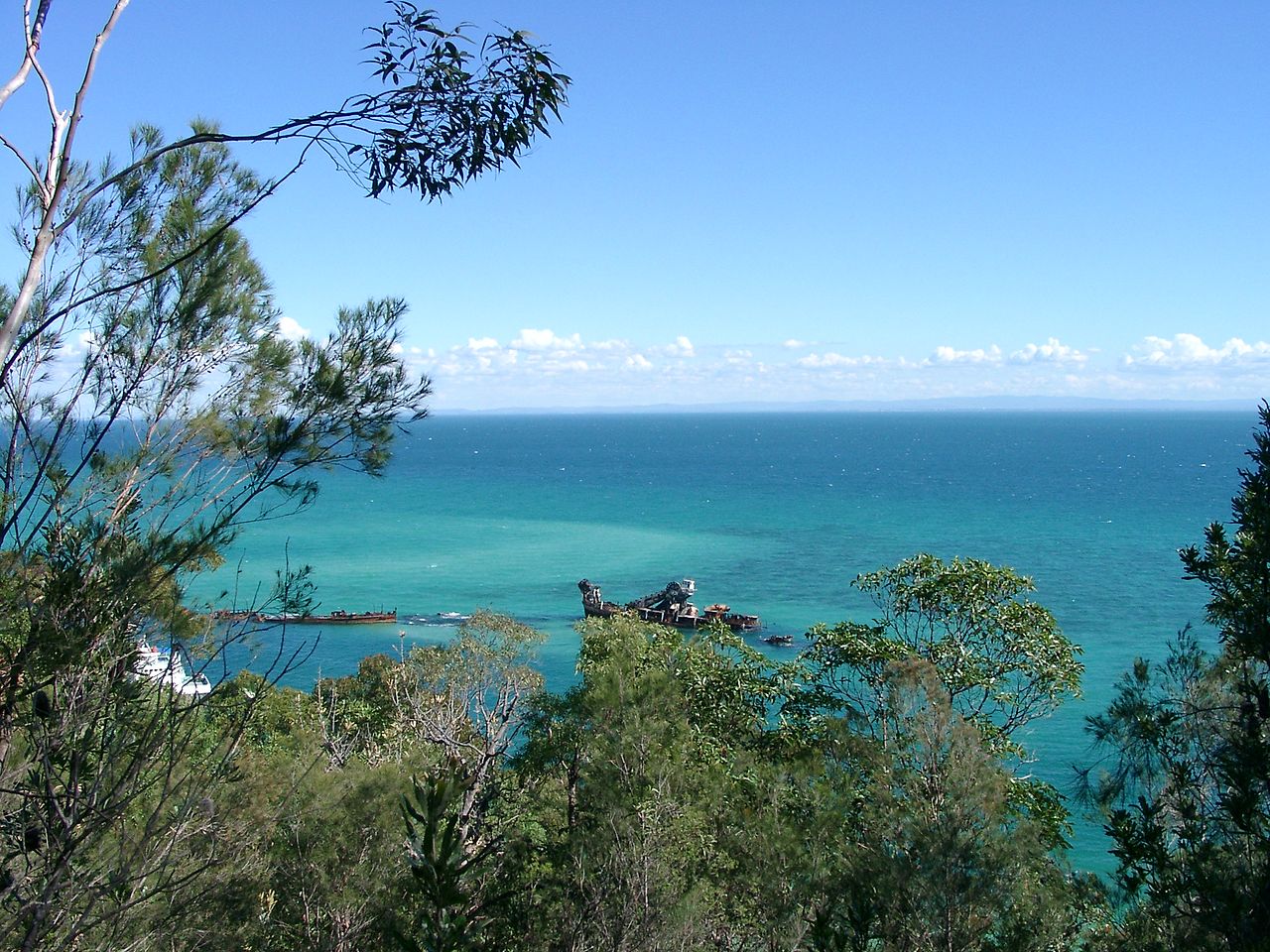
 The first of the Tangalooma Wrecks were placed in 1963, one year after the whaling station ceased operations.

Queensland's history—1800s | About Queensland and its government ...https://www.qld.gov.au/about/about-queensland/history/timeline/1800s
This report gives Oxley's impressions...


Robert Dixon (1800–1858) - Robert Dixon, This map of Moreton Bay, National Library of Australia, MAP RM 1074
This map of Moreton Bay. The first accurate map of Moreton Bay, Queensland. Compiled from authentic surveys and containing all the latest discoveries made by exploring parties is most respectfully dedicated to His Grace the Duke of Cleveland by his most obedient servant Robert Dixon. Based on trigonometric survey.
File:Dixon (1842).jpg
Created: 1 January 1842
Brisbane Courier (Qld. : 1864 - 1933), Thursday 18 November 1869, page 3 (3)
National Library of Australia http://nla.gov.au/nla.news-article1301802

Elevations and plans for conversion of Prisoners’ Barrack buildings, Moreton Bay, July 1839
Queensland State Archives has some great blog posts re the settlement of Moreton Bay - this is from just one of them.

.jpg)
.jpg¶ms=27.25_S_153.25_E_&language=en)
File:StateLibQld 2 148511 Early drawing of a section of the town of Brisbane, Queensland including the Convict Hospital, 1835.jpg
Created: 1826date QS:P571,+1826-00-00T00:00:00Z/9
It didn't take long before land was for sale and attracting southern interest... that hasn't changed really.
 Land for sale in Manly in 1887
Estate map of Manly Beach, Manly,1887. Map shows a plan of all blocks for sale in the Manly Estate, bounded by Gordon Parade, Mountjoy Terrace, The Espalande, Ernest Street and Spring Street. The auction was for New Year's Day 1887 and the auctioneers were Arthur Martin & Co. Many blocks front on to Moreton Bay and Waterloo Bay.
File:StateLibQld 1 130843 Estate map of Manly Beach, Manly,1887.jpg
Created: 1 January 1887

File:StateLibQld 2 148511 Early drawing of a section of the town of Brisbane, Queensland including the Convict Hospital, 1835.jpg
Created: 1826date QS:P571,+1826-00-00T00:00:00Z/9

File:StateLibQld 2 148511 Early drawing of a section of the town of Brisbane, Queensland including the Convict Hospital, 1835.jpg
Created: 1826date QS:P571,+1826-00-00T00:00:00Z/9
Biography - John Petrie - Australian Dictionary of Biographyadb.anu.edu.au/biography/petrie-john-4394
File:JohnPetrie01.jpg
Early Mayor of Brisbane


Moreton Bay Pile Light, circa 1912
 Sailing on Moreton Bay in 1915
Sailing on Moreton Bay, 1915.
One of the oldest surviving buildings of early Brisbane is the old Windmill... once the site of incredible cruelty, now the mecca for tourists interested in history. It was built by convicts in 1828 and had a treadmill, powered by convicts, for grinding grain.
Depiction of the 1841 hanging (Telegraph, 10 March 1970)

Courier-Mail (Brisbane, Qld. : 1933 - 1954), Tuesday 10 January 1950, page 2
National Library of Australia http://nla.gov.au/nla.news-article49709168

Old Windmill Brisbane | History of Brisbane
Old Windmill Brisbane
Brisbane’s oldest building has many facets to its sometimes dark and brutal history - built by convicts in the late 1820s, it is not just the longest surviving convict building but also the oldest windmill in existence in Australia.
At first seen as a folly due its ill-conceived often windless location, it morphed into a symbol of dread and torture as penal Commandant Patrick Logan used convicts to work a treadmill he had constructed to keep the arms turning in lieu of wind. As a punishment they would be set to work in 8kg leg irons for fourteen hours straight and in the burning sun to keep the maize grinding. Wearing only rough leather hats for protection they had to grasp an overhead rail using both hands and walk the 23cm wide steps continuously and if they missed a beat they’d be hit on the shins with the next step as it rose. The only way of getting off early was to collapse.
Andrew Petrie, the notable early settler and builder described how he would be disturbed by the constant ‘click click’ sound of the convicts’ irons as they tried to keep in step.
During that era two Aboriginal prisoners were hanged from a high window for the general public and their fellow tribesmen to see. The crime was the killing of a surveyor Granville Stapylton and his convict assistant William Tuck in 1840 in the coastal area south of Brisbane. Tuck was buried on the spot and Stapylton was buried in Brisbane’s first burial ground (now the park E McCormick Place) adjacent to William Jolly Bridge.
The mill continued to operate in the early days of free settlement and in 1861 became a signal station. From 1866 to 1894 a time gun went off at 1pm every day to announce the time and from 1894 to the 1950s a copper time ball (which still sits on the roof) was dropped at 1pm every day.
Significantly it was here in 1934 that the first television signals in the southern hemisphere were transmitted and this pioneering TV broadcasting continued up until World War II.
From the outside the windmill tower gives little indication that inside there are five floors, with a hexagonal staircase winding around an inner pole and up to the observation deck. The tiny windows just below the deck are a unique feature designed to let light into the top floor.

Fishing from the shore in Moreton Bay, 1936
Fishing from the shore in Moreton Bay, 1936 A group of fishermen are standing on the shoreline holding their fishing rods. A fishing basket is lying on the ground and an interested onlooker watches the action.
 The first of the Tangalooma Wrecks were placed in 1963, one year after the whaling station ceased operations.
File:Tangalooma Wrecks 2002-06-02.jpeg
Created: 2 June 2002

File:Queensland State Archives Digital Image ID 1105 ID label: 1080841 View of Beach showing Bribie Island and entrance to Pumicestone Channel Caloundra December 1930.png
Created: 1 December 1930
Further reading...
Immigration and Shipping State Library of Qld..http://www.slq.qld.gov.au/resources/family-history/immigration
The Chronological Register of Convicts at Moreton Bay (Series ID 5653) (Click on series ID for direct link to page)
The Not-So-Great-Escape
26 April, 2016 Qld State Archives
Life in Irons: Brisbane's convict stories highlight role of Aboriginal people in penal colony
http://www.abc.net.au/news/2018-06-02/life-in-irons-brisbanes-convict-stories-tell-of-aboriginal-role/9820010
Queensland's history—1800s | About Queensland and its government ...https://www.qld.gov.au/about/about-queensland/history/timeline/1800s
# Great example of making lists on TROVE and saving for reference
Body of Historical Evidence - Captain Cook's Endeavour to Australia - Lists - Trove
No comments:
Post a Comment
I welcome your comments. All will be moderated before publication.